Deep dive — charts
Latitude and longitude
Enter a coordinate and watch the chart point light up, or tap the chart and read the coordinate off; then find airports by coordinate the way the test asks.
Two angles that name a place
Every point on the Earth has an address made of two angles. Latitude says how far north or south of the equator you are, from 0 degrees at the equator to 90 at the poles. Longitude says how far east or west of the Prime Meridian you are, the line that passes through Greenwich, England, out to 180. The lower 48 states sit between about 25 and 49 degrees north and between about 67 and 125 degrees west.
The part that trips people is which line runs which way. A line of latitude runs east and west, like a rung of a ladder, but it measures how far you are north or south. A line of longitude runs north and south, from pole to pole, but it measures how far you are east or west. The direction a line runs is the opposite of the direction it measures. If you keep one fact, keep this one: a line of latitude is flat, and it counts north and south of the equator.
FAA-H-8083-25C, Ch. 16Degrees, minutes, and a mile
A degree is divided into 60 minutes, the same way an hour is. So 47°40’N means 47 degrees and 40 minutes north, two thirds of the way from the 47th parallel to the 48th. The apostrophe is the minute mark. Do not read it as a decimal.
The graticule on a sectional
The chart draws a grid of latitude and longitude lines, called the graticule. The lines are drawn every 30 minutes, and each carries tick marks, one for every minute. On these excerpts the labels sit on the whole-degree lines, so you work out the half-degree lines from their neighbors.
Because the numbers grow toward the north and toward the west, direction is settled before you count. Going up the chart, latitude gets bigger. Going left, longitude gets bigger. To find a point, pick the nearest labeled line for each axis, count ticks in the right direction, and see where the two counts meet. Counting from whichever line is closer, a labeled degree line or a 30-minute line, keeps the count short and the errors small.
Aeronautical Chart Users' Guide, VFR Terms and Symbols · FAA-H-8083-25C, Ch. 16The FAA’s two sample points
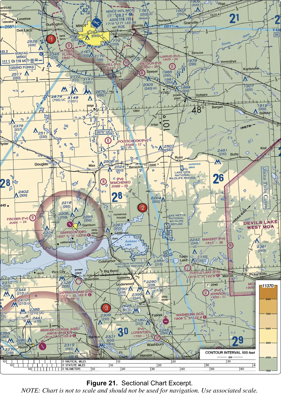
The first is sample question 24, on Figure 21. It asks which airport is at 47°40’N and 101°26’W. The choices are Mercer County Regional, Semshenko and Garrison. Do the count. The 48°N line and the 101°W line are labeled on the chart. Your latitude is 20 minutes below the 48° line, which is the same as 10 minutes above the unlabeled 47°30’ line. Your longitude is 26 minutes west of the 101° line, which is 4 minutes east of the 101°30’ line. Where those counts cross is Garrison Airport (D05). Mercer County is about twenty minutes of latitude farther south, and Semchenko is a private strip a little to the north and east. When you plot it below, the readout under the point should name Garrison. The plotter is fitted to the chart’s own graticule and is good to about a minute, so expect it to agree with your hand count to within a mile or so, not to the foot.
The second is sample question 13, on Figure 26. It gives the coordinates in decimals: 46.9N and 98.6W, near Jamestown Regional, and asks what you must receive before flying there to inspect a tower. Convert first. Point nine of a degree is 0.9 times 60, which is 54 minutes, so the latitude is 46°54’N, six minutes south of the 47° line. Point six of a degree is 36 minutes, so the longitude is 98°36’W. On the plotter that point falls a little southeast of the Jamestown symbol, inside the dashed magenta line of a Class E surface area. That is why the answer is authorization from ATC.
FAA-CT-8080-2H, Figures 21 and 26 · 14 CFR § 107.41The trap in decimal degrees
Chart coordinates are in degrees and minutes. A phone or a GPS app prints decimal degrees. The question writer knows this, and question 13 is written in decimals on purpose. The mistake is to read 46.9 as 46 degrees 9 minutes, or as 46 degrees 90 minutes. Neither exists: 46.9 is 46°54’. To convert, multiply the part after the point by 60. To go back, divide the minutes by 60.
Three experiments
The plotter accepts coordinates in several forms: 47°40’N, 101 26 W, or 46.9N. Use whichever is quickest. You can also go the other way: tap anywhere on the chart and read its coordinate off the readout.
- Plot Question 24 on Figure 21 and read the airport under the point. Then change the longitude to 101°30’W, which moves you four minutes west. Watch the readout stop naming Garrison and name the faded Class E ring around it instead. Four minutes of longitude is only about 2.7 nautical miles at this latitude, and that small a slip is the whole difference between the airport and the empty ground beside it.
- Switch to Figure 26 and plot 46.9N and 98.6W. Note where it lands relative to the symbol. Then type the same point as 46 54 N and 98 36 W, and you land in the same place. Now type 46 9 N. The plotter tells you the point is off this excerpt, because 46°09’ is 45 minutes farther south than you meant to be. That is the decimal trap, made visible.
- Turn on practice and work Figure 22. The plotter names a coordinate and asks you to tap the airport. Count the ticks before you tap. Then try plotting one coordinate with the hemisphere letter left off. A longitude with no W is read as east, and the point lands off the chart, which is why the letters on a test question matter.
How the test asks it
FAA-CT-8080-2H, Figures 21 and 26 · FAA-H-8083-25C, Ch. 16Where to go next
If you plotted both sample points and your tap in practice mode landed on the right airport, you have the procedure. To see what the symbols around those points mean, go back to reading a sectional. For the full chapter, including how coordinates sit alongside scale and distance, read the charts chapter.
Plot a coordinate. Or tap the chart and read one off.
- Latitude
- —
- Longitude
- —
- Under the point
- —
Latitude lines run east–west and are counted north of the equator; longitude lines run north–south and are counted west of Greenwich. On a sectional each tick on the graticule is one minute. The coordinates here come from a fit to the chart's own graticule and are good to about a minute.