Deep dive — weather
Decoding METAR and TAF
A real-format METAR lights up one token at a time with its plain meaning; then decode a fresh one and get checked, and read a TAF's change groups.
A METAR is a sentence with a fixed word order
A METAR looks like line noise: KMDW 121856Z 32005KT 1 1/2SM RA OVC007 17/16 A2980. It is actually a sentence in which every word has an assigned slot, in an order that never changes. Wind is always the first thing after the time. Visibility is always next. Cloud comes after weather, temperature after cloud, pressure last. Once you know the slots, you never have to figure out what a token is, only what it says. A token that starts with A and has four digits in the last position can only be the altimeter. A token ending in KT can only be wind.
That fixed order is the whole trick, and it is why this lesson has you decode reports by hand instead of memorizing a legend. The legend is short. The skill is looking at a token, knowing which slot it fills, and reading it without second-guessing. FAA-H-8083-28B, Ch. 24.4 (METAR/SPECI)
Why this matters to you in particular. The test asks about METARs in a narrow, predictable way: what is the wind, and what are the sky and visibility? Those are not arbitrary. Visibility is a regulation: your flight visibility, observed from where you stand at the control station, must be at least 3 statute miles. 14 CFR § 107.51(c) The lowest cloud layer feeds the other half: you must stay at least 500 feet below any cloud and 2,000 feet away from it horizontally. 14 CFR § 107.51(d) Part 107 never uses the word “ceiling”, but a low ceiling is just a low cloud base, and a low cloud base is what squeezes the room you have beneath it. Wind is the third thing, and it is the one that decides whether a 5-pound aircraft can hold position at all.
The word order, token by token
Here is the report from the top of the page again, with the slots numbered in the order you will see them. The chapter covers each group in depth; this section is the one-line version plus the trap hiding in each slot. FAA-H-8083-28B, Ch. 24.4.3
- Type.
METARis the routine hourly report.SPECIis a special report, issued any time something significant changes (a wind shift, visibility crossing a threshold, a thunderstorm starting, the ceiling crossing a threshold). Websites often drop the wordMETAR, so a report may begin straight with the station. A SPECI means conditions are changing fast, so read it with extra care. FAA-H-8083-28B, Ch. 24.4 - Station. Four letters, and in the contiguous states it is a
Kplus the usual three-letter code.KMDWis Chicago Midway. - Day and time.
121856Zis the 12th day of the month at 18:56 UTC. The trap is the clock: Z is Zulu time, not your local time. A report stamped1856Zis hours earlier or later than it looks to you, depending on where you live. Check how old the report is before you trust it. - Modifier.
AUTOmeans a machine made the report with no human editing;CORmeans a correction. Neither changes how you read the rest. - Wind.
32005KTis three digits for direction, two for speed, then the unit. Wind from 320 degrees at 5 knots. Two traps live here. The direction is true north, not magnetic, and the speed is in knots. Gusts follow aG:27020G35KTis from 270 at 20, gusting to 35.VRB03KTis variable direction at 3 knots, and00000KTis calm. FAA-H-8083-28B, Ch. 24.4.3.5 - Visibility.
1 1/2SMis one number, one and a half statute miles, even though a space splits it in two. The whole number and the fraction belong together.10SMis ten miles. APin front (P6SM) means “more than”, and anMin front of the fraction (M1/4SM) means “less than”. FAA-H-8083-28B, Ch. 24.4.3.6 - Runway visual range (only when visibility is a mile or less).
R04R/2200V2600FTis runway 04 right, 2,200 to 2,600 feet. You only have to recognize it as RVR; it is a runway measurement and says nothing about your flight visibility. - Present weather. Zero, one or several groups: intensity, then descriptor, then phenomenon. The table below has the ones the test uses. No weather worth reporting means no group at all.
- Sky condition. Layers from lowest up, each an amount and a three-digit height in hundreds of feet above ground level.
OVC007is overcast at 700 feet.BKNandOVCmake a ceiling;FEWandSCTdo not.VV002is vertical visibility into fog and counts as a ceiling too. This is the trap that costs the most points, so say it twice: a scattered layer is not a ceiling. FAA-H-8083-28B, Ch. 24.4.3.9 - Temperature and dew point.
17/16is 17 and 16 degrees Celsius. AnMmeans minus:04/M02is 4 above and 2 below zero. When the two numbers are within 2 degrees of each other, fog and low cloud are close. FAA-H-8083-28B, Ch. 24.4.3.10 and 18.1.1 - Altimeter.
A2980is 29.80 inches of mercury. Drop the letter, put a decimal point after the second digit. Standard isA2992. - Remarks. Everything after
RMKis extra detail. The test does not ask you to decode it; real remarks such asRAB35(rain began 35 minutes past the hour) are worth a glance on a marginal day.
| - and + | Light and heavy. No sign at all means moderate. | 24.4.3.8 |
|---|---|---|
| RA | Rain | 24.4.3.8 |
| SN | Snow | 24.4.3.8 |
| BR | Mist (visibility 5/8 mile to under 7 miles) | 24.4.3.8 |
| FG | Fog (visibility under 5/8 mile) | 24.4.3.8 |
| HZ | Haze | 24.4.3.8 |
| SH | Showers (SHRA: rain showers) | 24.4.3.8 |
| TS | Thunderstorm (TSRA: thunderstorm with rain) | 24.4.3.8 |
| FZ | Freezing (FZRA: freezing rain; FZFG: freezing fog) | 24.4.3.8 |
| VC | In the vicinity, roughly 5 to 10 miles from the station | 24.4.3.8 |
Read present weather left to right and it assembles itself. +TSRA is a heavy thunderstorm with rain. -SHSN is light snow showers. VCTS is a thunderstorm nearby. FAA-H-8083-28B, Ch. 24.4.3.8
The FAA’s own set, read aloud
The knowledge test supplement prints five reports in one figure. Two of them have been used for sample questions. Look at the figure, then read these in prose the way the test wants.
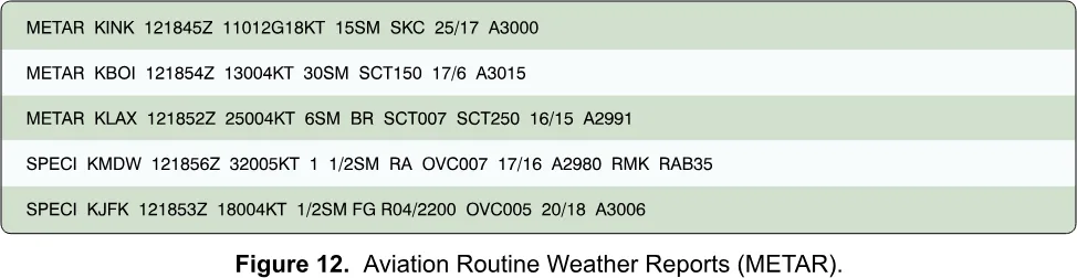
KMDW: SPECI KMDW 121856Z 32005KT 1 1/2SM RA OVC007 17/16 A2980 RMK RAB35. A special report at Midway on the 12th at 18:56 UTC. Wind from 320 degrees true at 5 knots. Visibility one and a half miles in rain. Overcast at 700 feet, which is a ceiling. Temperature 17, dew point 16, one degree apart, so the air is close to saturated and the low cloud and rain are not about to lift. Altimeter 29.80, below standard. The sample question asks what the current conditions are, and the right answer is “sky 700 feet overcast, visibility 1-1/2SM, rain”. The wrong answers dress this up: 7,000 feet instead of 700, “heavy” rain when there is no plus sign, and “11, occasionally 2SM” which is a pair of numbers misread out of 1 1/2SM. FAA UAG Sample Questions, Q25
Now apply Part 107. One and a half miles is under 3, so you cannot legally fly here. Full stop. Even if the visibility were fine, a 700-foot overcast leaves you 300 feet below the cloud if you were at 400 feet, and the rule asks for 500. You would have to stay at or below 200 feet. 14 CFR § 107.51(c) and (d)
KJFK: SPECI KJFK 121853Z 18004KT 1/2SM FG R04R/2200V2600FT OVC005 20/18 A3006. Wind from 180 degrees true at 4 knots. Visibility half a mile in fog. Runway visual range on 04 right is 2,200 to 2,600 feet. Overcast at 500 feet. Temperature 20, dew point 18. Altimeter 30.06. The sample question asks only about the wind, and the right answer is 180 degrees true at 4 knots. The distractors are the same wind labeled magnetic, which tests whether you know METAR wind is true, and “040 at 18 knots”, which is what you get by reading the digits of 18004 in the wrong places. FAA UAG Sample Questions, Q26
Both of these are reports where flight would be illegal and unwise. The other three in the figure (KINK, KBOI, KLAX) are fine or nearly fine. KINK gusts to 18 in clear air and 15 miles of visibility. KBOI has 30 miles and a scattered layer far above you. KLAX has 6 miles in mist and scattered cloud at 700 feet: not a ceiling, but a layer you must still keep 500 feet below, so you would be limited to 200 feet or have to stay 2,000 feet horizontally from it.
Using the decoder below
Start in Walkthrough mode. The report picker defaults to a Figure 12 report. Press Next token and watch each token light up with its slot name and a plain reading. Before you press the button, say aloud what you think the next token will say. The first five reports in the picker are exactly the FAA’s, so if you can step through those without surprises you have done the test’s METAR material. Then use the full table to check yourself, and try the later reports, which add the things the test supplement does not show: variable wind, thunderstorms with towering cumulus, a negative temperature.
Then switch to Practice. It draws a fresh report you have not seen and asks about the wind, the visibility, the lowest cloud layer and the temperature. Do not move on until you answer every question right on several reports in a row. If you get one wrong, look at the chips at the top of the screen and notice which slot you misread. Most people have one habit: reading SCT as a ceiling, forgetting M, or missing the fraction in the visibility. Find yours.
TAF: the same language, pointed forward
A METAR tells you what is happening. A TAF, a terminal aerodrome forecast, tells you what is expected to happen at one airport over the next day or so. It uses the same code, the same units and the same sky and weather tokens, so you already know most of it. A TAF covers the area within 5 statute miles of the center of the runway complex, is valid for 24 or 30 hours, and is issued four times a day. There is no temperature in a TAF and the only cloud type it ever includes is CB. FAA-H-8083-28B, Ch. 27.4 (TAF)
The new part is the header and the change groups. The header gives the station, the time of issue, and the valid period. In the decoder’s example, KMEM 121720Z 1218/1324, the forecast was issued on the 12th at 17:20 UTC and runs from the 12th at 18:00 UTC to the 13th at 24:00 UTC. The two slash-separated pairs are day and hour, and hour 24 means the end of that day. After the header comes the base forecast, which is the prevailing conditions at the start. Then change groups modify it. FAA-H-8083-28B, Ch. 27.4.2.1-4
- FM (“from”) is a clean break. From the stated time, everything after it replaces the previous forecast, and every element is restated. Use FM when the change is rapid, usually within an hour.
FM130100means from the 13th at 01:00 UTC. FAA-H-8083-28B, Ch. 27.4.2.10.1 - TEMPO is a temporary fluctuation: it is more likely than not to happen, lasts an hour or less at a time, and covers less than half of the window it names. Only the changed elements appear. If the base forecast says 5 miles in haze with a ceiling at 3,000 and
TEMPO 1314/1318says3SM SHRA BKN020, then at times between 14:00 and 18:00 UTC expect 3 miles in rain showers with the ceiling down at 2,000. FAA-H-8083-28B, Ch. 27.4.2.10.2 - BECMG (“becoming”) is a gradual change that finishes somewhere inside its window. Afterward the new conditions are the ones that apply until something else changes them.
BECMG 1310/1312completes by 12:00 UTC on the 13th. The handbook’s NWS format does not list BECMG, but the test supplement’s TAF figure uses it. FAA-H-8083-28B, Ch. 27.4.2.10.4 - PROB is a probability.
PROB40is a 40 percent chance of the stated weather in the stated window, usually thunderstorms or precipitation. The National Weather Service usesPROB30in its own TAFs, but the figure on the test and the military and international forecasts usePROB40, so recognize both. FAA-H-8083-28B, Ch. 27.4.2.10.3
Switch the decoder to TAF mode and click through the groups. Each shows its time window in words and then reads the tokens inside. Notice that the base, the PROB40 thunderstorm, the FM and the later groups all use the same visibility, wind and sky tokens you just practiced.
Where to get them
Both come free from the National Weather Service’s Aviation Weather Center at aviationweather.gov, which needs no account and carries METARs, TAFs and the other products a remote pilot needs. Flight Service runs 1800wxbrief.com, where a remote pilot can make a free account and get a standard briefing; its telephone service is for manned-aircraft pilots only. AC 107-2A, App. B.3 Check temporary flight restrictions separately, at tfr.faa.gov.
Whichever source you use, remember the geography. The report comes from an airport, possibly miles from your launch point, and the TAF speaks for 5 miles around one runway complex. Your own flight visibility, observed where you are standing, is what the regulation asks about. Use the METAR to tell you where to look, then look.
What to take from this
Having used the decoder below, you should be able to do four things without hesitating. Find the wind token, read direction as true and speed as knots, and handle a gust. Read visibility as a single number, including the 1 1/2 form. Name the lowest ceiling, remembering that only BKN, OVC or VV count, and read the height as hundreds of feet above ground. Read a TAF’s valid period and say in plain words what FM, TEMPO, BECMG and PROB each promise.
Next, a METAR gives you the temperature, the dew point and the altimeter setting, which feed into density altitude, the thing that changes how a drone performs on a hot afternoon at a high field. The density altitude lesson takes those numbers and shows what they do to your aircraft. For the rest of the weather material, return to the weather chapter.
Read a METAR one token at a time.
The first five reports are the ones in the FAA testing supplement's Figure 12, exactly as printed. Tap any token to jump to it. In practice mode a fresh report is drawn and you are asked the three things the test asks.