Deep dive — charts
The chart's airspace rings
The same chart excerpts with airspace classes toggled on one layer at a time, each ring's floor and ceiling explained where it is drawn.
Four lines, two inks
You are about to look at airspace one class at a time, so it helps to know what each class looks like when it is not highlighted. Two inks carry the whole system, and within each ink the busier airspace gets the solid line.
Class B is a solid blue line. Class C is a solid magenta line. Class D is a dashed blue line, and Class E that reaches the surface is a dashed magenta line. So blue and magenta are the pairs, B and D in blue and C and E in magenta, and the solid ones are the heavier controls. Those four lines are the ones that matter most to you, because inside any of them 14 CFR § 107.41 requires prior authorization before you fly.
Two softer marks sit around them. A faded magenta band, the magenta vignette, means Class E that begins 700 feet above the ground. A blue vignette means a floor of 1,200 feet or more above the ground where controlled air gives way to Class G. Then there is special-use airspace, which is hatched rather than drawn as a clean line: restricted and warning areas are blue hatching, and military operations areas and alert areas are magenta hatching.
Aeronautical Chart Users' Guide, VFR Terms and Symbols · 14 CFR § 107.41The numbers on a ring
Each ring carries a pair of numbers, one above the other like a fraction without the bar. The top number is the ceiling and the bottom number is the floor. Both are in hundreds of feet above mean sea level, with the last two zeros left off. The color of the figures matches the line: Class B in blue, Class C in magenta.
| 41 over SFC | Surface to 4,100 ft MSL | Class C inner circle |
|---|---|---|
| 41 over 13 | 1,300 ft MSL up to 4,100 ft MSL | Class C shelf |
| [25] | Surface up to 2,500 ft MSL | Class D ceiling, in a box |
| [-25] | Surface up to, but not including, 2,500 ft MSL | minus sign |
| + before a floor | From above that altitude | Class B floors |
| T as a ceiling | Up to, not including, the floor of the overlying Class B | Class C only |
| 3400 MSL, zigzag line | Class E from 3,400 ft MSL up | a floor above 700 ft AGL |
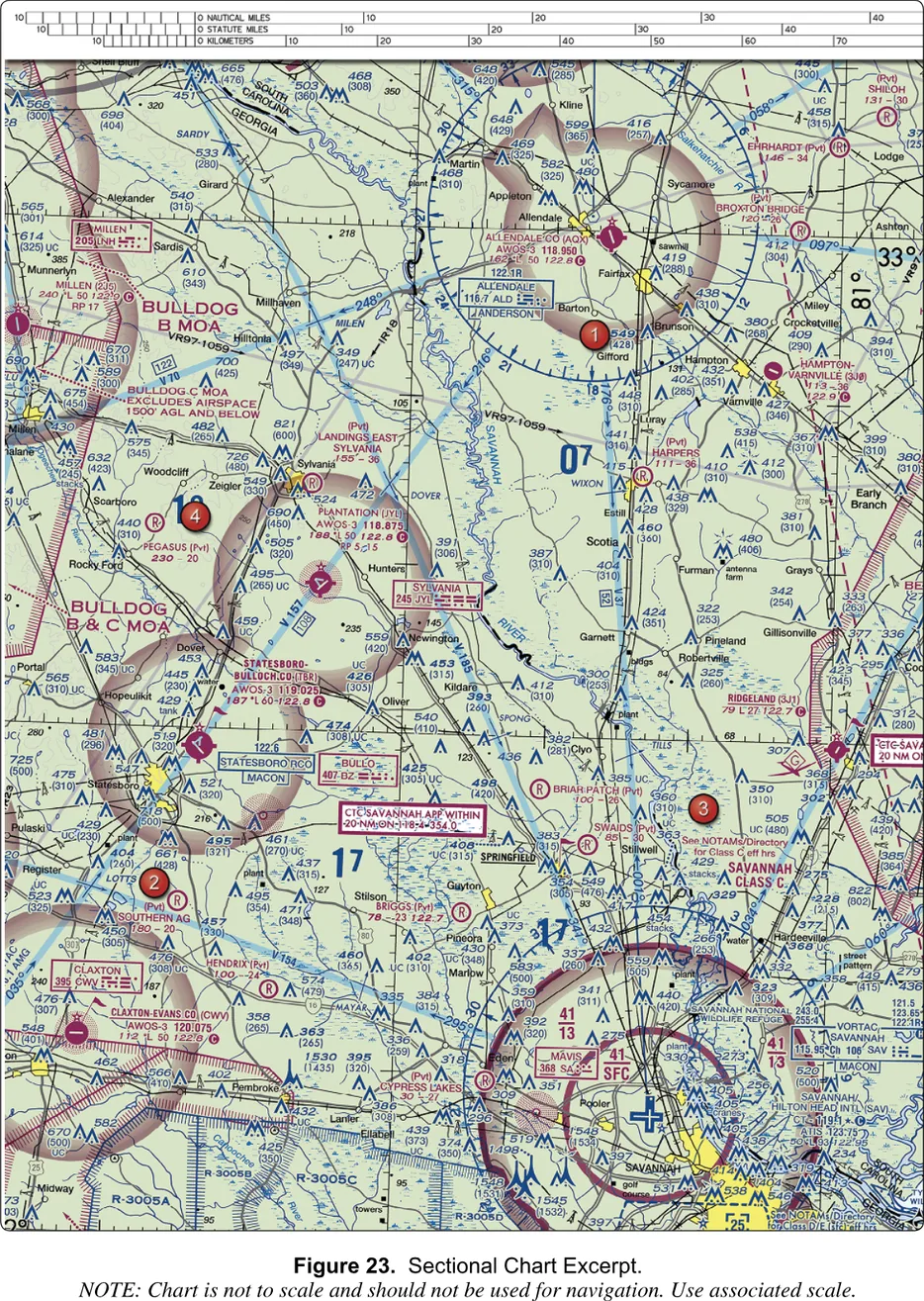
Savannah, on Figure 23, is the worked example, and it is exactly sample question 8. The question points at area 3 and asks for the floor of the Savannah Class C at the shelf, the outer circle. The inner circle is labeled 41 over SFC, from the surface to 4,100 feet. The outer shelf, where area 3 sits, is labeled 41 over 13: a ceiling of 4,100 and a floor of 1,300, so the Class C there starts at 1,300 feet MSL. The answer is 1,300 feet MSL. The other choices are the same number in the wrong unit and a number that is not on that ring at all.
Notice also why Savannah’s ceiling is 41 and Norfolk’s is 40. A Class C ceiling is 4,000 feet above the airport, converted to MSL and rounded. Savannah’s field is at 50 feet, which gives about 4,100. Norfolk’s is at 27 feet, which gives about 4,000. The notation is not arbitrary, and you can check it.
Reading a ring from your own altitude
The rings are in MSL and your altitude limit is in AGL. The difference is the ground under you. To compare, add the field or ground elevation to your height: your top is the ground elevation plus up to 400 feet.
At Savannah International the field is 50 feet above sea level, so a drone at 400 feet AGL there is at about 450 feet MSL. The shelf floor is 1,300 MSL. You are 850 feet below it, so the shelf is no concern. The inner circle is the problem: 41 over SFC reaches the ground, so inside it you are in Class C and need authorization. The pattern repeats. A shelf is rarely what catches a small drone at low ground. The surface ring is, so find that first. A shelf can matter where the ground is high, where 400 feet above it climbs to meet a floor.
14 CFR § 107.51(b) · 14 CFR § 107.41 · Aeronautical Chart Users' Guide, VFR Terms and SymbolsNorfolk: a Class C with holes in it, and the water offshore
Figure 20 is the busiest of the five. Norfolk International (ORF) has a solid magenta Class C. Its inner circle reads 40 over SFC: surface to 4,000 feet MSL. The shelf is not one number. One part reads 40 over 12, a floor of 1,200 feet, and another reads 40 over 20, a floor of 2,000 feet, so the underside of the cake is not one height all the way around.
Dashed blue rings sit in and around it: a Class D with a boxed 20 for Chambers Field, a ceiling of 2,000 feet MSL cut out of the Class C shelf, and boxed 25s for the Langley and Newport News area. Those are Class D ceilings, 2,500 feet MSL. A dashed magenta circle at Fentress marks Class E to the surface, next to a caution box about high-density military operations.
Offshore the blue hatched shapes are the warning areas W-50A, W-50B and W-50C, with the restricted area R-6606 along the beach. A warning area extends from three nautical miles out from the coast and may contain hazards such as missile firing or gunnery. Zigzag blue lines mark Class E floors in MSL numbers, 1700 and 5500, far above anything you will fly. The tap legends for these say that altitudes and times are in the chart margin, which these excerpts do not include.
Aeronautical Chart Users' Guide, VFR Terms and Symbols · 14 CFR § 107.45Three experiments
- Open Figure 23 and switch on only Class C. Tap the inner ring, then the outer ring on either side of the airport, and read the floor and ceiling for each. Then add Class D and find the boxed 25 in the southeast.
- Open Figure 20, switch on Class C and Class D together, and find where the Class D sits inside the Class C shelf. Turn Class C off and watch the shape the D leaves. Then switch to Special use only and see how much of the picture is warning areas over water.
- Open Figure 22 and switch on only Class E. The tint covers the dashed line around Coeur d’Alene, the vignettes, and the Victor airways. Tap each one and sort them into two piles: Class E that starts at the ground, and Class E that starts above you. Only the first pile needs authorization from a drone. Then switch Class B on, on any of the five. Nothing lights, because none of these excerpts has a Class B. The Class B in the printed supplement is on Figure 25, which this reader does not include.
How the test asks it
FAA-CT-8080-2H, Figures 23 and 26 · 14 CFR § 107.41Where to go next
You can now tell a line from a vignette and a floor from a ceiling. The rules behind them, including how LAANC gets you authorization, are built up from the ground in airspace from the ground up. The rest of the chapter, with all the symbols, is in the airspace study chapter.
The airspace rings, one layer at a time.
Real excerpts from the FAA testing supplement. Drag to pan, pinch or scroll to zoom. Since October 2026 the test can show you a current sectional of any region; the symbols and the reading method are the same as on these.