§ 3 — Airspace
Airspace
The alphabet of airspace, what each class means for a small drone, who you must ask before you fly, and where to look it up.
A fifth of the test is airspace, and most of it comes down to one habit: before you launch, work out which pieces of sky are stacked above your launch point and who, if anyone, has to say yes. None of it is hard once you see why the sky is carved up the way it is. Every line on a sectional chart answers a practical question: who is up here, how fast, and who is watching them?
A note on figure numbers. The plates in this chapter carry chapter numbers (plate 3-2, plate 3-4). The FAA’s test supplement has its own numbers (Figure 25, Figure 23). I give both, because the test will use only the second kind.
§ 3.1 — WHY AIRSPACE EXISTS
Why the sky is divided up
Separating who from whom
The sky looks empty, and that is exactly the problem. Two aircraft closing at a combined 300 knots cover a nautical mile in twelve seconds, and a pilot in a cockpit sees a small object late or not at all. So aviation does not depend on everyone looking hard. It organizes the sky so that the places with the most traffic, the fastest traffic, or the most dangerous activity get extra structure: someone watching on radar, rules about who may enter, equipment that must be on board. Where there is little traffic, the structure is light or absent.
That is the whole logic of the airspace classes. The FAA names the criteria: the complexity or density of aircraft movements, the nature of the operations, the level of safety required, and national and public interest. Busy airports get more structure. Open country gets almost none.
FAA-H-8083-25C, Ch. 15The FAA sorts airspace into four types, and the rest of the chapter walks through them in order. Controlled airspace is where air traffic control (ATC) provides service. Uncontrolled airspace is where it does not. Special use airspace confines hazardous or sensitive activity. Other airspace is the miscellany: military training routes, parachute drops, temporary restrictions.
FAA-H-8083-25C, Ch. 15 · FAA-G-8082-22, Ch. 2What ATC does, and what it does not do for you
The primary purpose of the ATC system is to prevent collisions between aircraft and to organize and expedite the flow of traffic. Anything beyond that, such as traffic advisories, is provided only as far as workload, radar quality, and frequency congestion allow. Controllers manage a flow; they do not chaperone every aircraft.
FAA-H-8083-25C, Ch. 15Here is where your aircraft differs from every other aircraft in the system. Part 107 says that, unless the FAA authorizes otherwise, you may not operate with a transponder on or with ADS-B Out transmitting. Those are the devices that make a manned aircraft visible to radar and to other aircraft’s equipment. So by design a small drone is invisible to the traffic system, and nobody can separate you from other traffic unless you tell them where you will be. An authorization is exactly that: your plan, placed on the controller’s picture before you launch.
14 CFR § 107.52 · 14 CFR § 107.53MSL and AGL: two ways to say “how high”
Every altitude in this chapter is one of two kinds, and the test will try to catch you mixing them. MSL is height above mean sea level. AGL is height above the ground directly beneath you. Stand on a 1,000-foot hill and fly 400 feet up, and you are at 400 AGL and 1,400 MSL.
As a rule of thumb for charts, the boundaries of Class B, C, and D are printed in MSL, and the common Class E floors are stated in AGL. Your own ceiling is AGL: 400 feet above the ground, or within a 400-foot radius of a structure and no higher than 400 feet above that structure’s top.
14 CFR § 107.51(b)Three layers to check before every flight
Treat any patch of sky as three overlapping layers. First, the class: what is the permanent classification at your location and altitude? Second, special use and other fixed areas: is there a restricted area, a military training route, a parachute zone? Third, the temporary layer: is there a TFR or a NOTAM today? The first two are printed on the chart. The third never is, because it did not exist when the chart was printed.
14 CFR § 107.49(a)(2) · AC 107-2A, § 5.10§ 3.2 — THE ALPHABET
The alphabet: Classes A through G
The classes run from A, the most restrictive, to G, the least. (There is no Class F in the United States.) Here is the stack in one picture before we take the classes one at a time. The vertical scale is squeezed to make everything fit, and the horizontal axis is not a scale at all, so use it for shape and not for measurement.
Look at the orange line. Everything you do happens in the thin strip beneath it. For an airliner the bottom of Class B or C is somewhere to stay high above. For you the bottom is the whole game, because the cylinders and cakes come down to the ground at their middle. That is why a drone pilot cares about shapes that look irrelevant to someone flying at 5,000 feet.
Class A
Class A runs from 18,000 feet MSL up to and including flight level 600 (about 60,000 feet), and includes the airspace over the water out to 12 nautical miles from the coast of the 48 contiguous states and Alaska. Unless otherwise authorized, everything in it is flown on instruments. Visual charts do not depict it at all.
FAA-H-8083-25C, Ch. 15 · FAA Chart Users' Guide, AirspaceYou will never be here: 18,000 feet is forty-five times your ceiling. It matters for the test only so you can say what it is. It is also why Class E “stops” at 18,000: above that, Class A takes over.
Class B: the upside-down wedding cake
Class B surrounds the nation’s busiest airports, measured by operations or passengers. It generally runs from the surface to 10,000 feet MSL, but each one is individually tailored: a surface area and two or more layers, each wider than the one below, so that the whole resembles an upside-down wedding cake. The design goal is practical. It is built to contain every published instrument procedure at that airport, so an aircraft that enters stays inside it for the whole procedure. ATC clearance is required for every aircraft, and every one that is cleared gets separation service.
FAA-H-8083-25C, Ch. 15 · FAA-G-8082-22, Ch. 2For you the cake has a rule and a catch. The rule is § 107.41: no one may operate a small unmanned aircraft in Class B without prior ATC authorization. The catch is that the cake comes all the way to the ground at its middle, so close to a major airport there is no altitude at which you are outside it.
14 CFR § 107.41How it is drawn. Class B is a solid blue line. Each sector carries a pair of blue numbers, ceiling over floor, in hundreds of feet MSL with the last two zeros dropped: 110 over 30 means 11,000 feet MSL at the top and 3,000 at the bottom. A floor marked “SFC” is the surface. A plus sign before a floor means “from above this altitude,” so at and below that altitude you are outside the Class B.
FAA Chart Users' Guide, Airspace · FAA-CT-8080-2H, Legend 1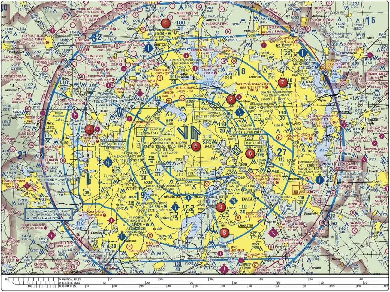
In Figure 25 (plate 3-2), DFW (area 5) sits at the center of the rings. The numbers show a core of 110 over SFC, then rings whose floors climb as you move outward (110 over 20, 110 over 30, and so on). The ceiling is 110, or 11,000 feet, so “10,000 feet” is a generality and not a law. Beside the big cake sit smaller dashed-blue Class D bubbles, around Addison and Arlington for example. A drone near Arlington is in a different class from one near DFW, and the line style tells you which.
The Mode C veil. The large thin ring labeled “MODE C 30 NM” on that plate is not Class B. Within 30 nautical miles of the primary airport of a Class B, from the surface to 10,000 feet MSL, a manned aircraft needs a transponder with altitude reporting (Mode C) and ADS-B Out. It is a rule about equipment on manned aircraft. A drone pilot inside the veil but outside the cake does not need § 107.41 authorization on that account.
FAA Chart Users' Guide, Other Airspace AreasClass C: two rings
Class C surrounds airports that have an operating control tower, radar approach control, and a certain level of instrument traffic or passengers. It is smaller than Class B and roughly a two-tier cake. The typical layout is a surface area with a five-nautical-mile radius from the surface to 4,000 feet above the airport elevation, plus an outer shelf with a ten-nautical-mile radius from 1,200 feet to 4,000 feet above the airport elevation. Each one is tailored, so the circles are only typical. Pilots of manned aircraft must establish two-way radio contact before entering and keep it while inside.
FAA-H-8083-25C, Ch. 15What this means for you. The inner circle goes from the surface up, so inside it § 107.41 applies at any altitude you can reach. The outer ring does not start until 1,200 feet above the airport’s elevation. A drone limited to 400 feet AGL, over level ground in the shelf area, is below the shelf, so it is in whatever airspace lies under it: Class E or Class G, unless another airport’s surface area claims that ground.
14 CFR § 107.41 · FAA-H-8083-25C, Ch. 15Now the catch from earlier. The shelf’s floor is a fixed MSL number printed on the chart, not a distance above your head. If the ground under the shelf rises 800 feet or more above the airport’s elevation, your 400 feet AGL puts you at or above the floor and inside the Class C.
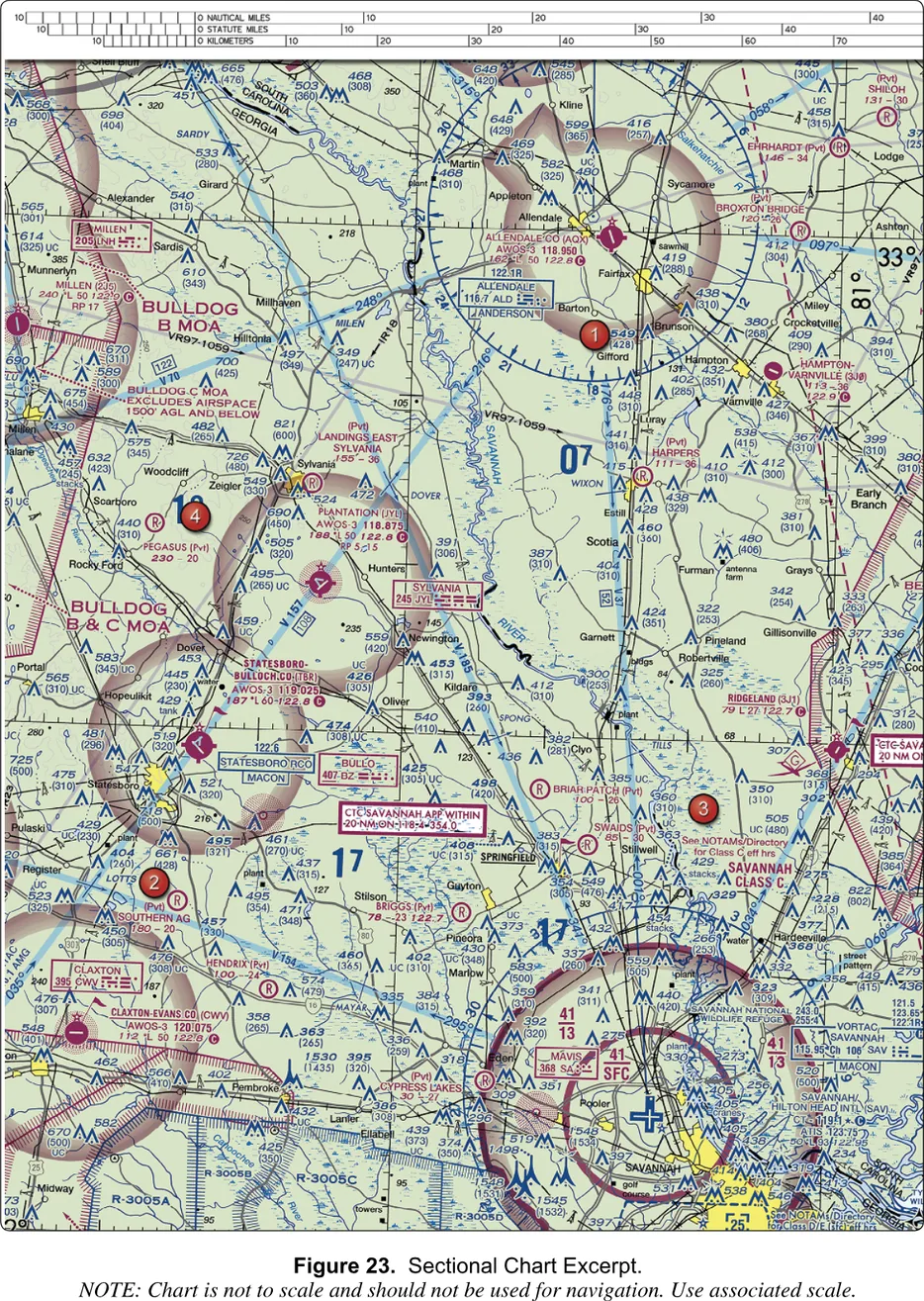
In Figure 23 (plate 3-4), find Savannah at the bottom right. The inner circle is labeled 41 over SFC and the shelf is labeled 41 over 13. In plain words: the ceiling is 4,100 feet MSL (4,000 above the airport’s 50-foot elevation, rounded up), the core goes to the ground, and the shelf starts at 1,300 feet MSL. The test asks the shelf floor at area 3 and offers 1,300 AGL, 1,300 MSL, and 1,700 MSL. Class C numbers are always MSL, so the answer is 1,300 feet MSL.
FAA Chart Users' Guide, Airspace · FAA-CT-8080-2H, Fig. 23The magenta box “CTC SAVANNAH APP WITHIN 20 NM” tells manned pilots whom to call, generally within 20 nautical miles. The note “See NOTAMs/Directory for Class C eff hrs” says the Class C is not necessarily in effect all day. That is the first hint of why the chart and the Chart Supplement work as a pair (see the airport section).
Class D: the dashed blue bubble
Class D surrounds airports with an operating control tower but without the radar and traffic volume of a Class C. It generally runs from the surface to 2,500 feet above the airport elevation, charted in MSL. Where instrument procedures exist, the airspace is built to contain them, and approach extensions may be Class D or Class E. Manned aircraft must establish two-way radio contact before entering. The FAA text mentions four nautical miles and 2,500 feet when it describes where a pilot must be in contact with a tower, so “about 4 NM” is a fair picture, but the shape is tailored to each airport.
FAA-H-8083-25C, Ch. 15How it is drawn. Class D is a dashed blue line. The ceiling sits in a dashed bracket, in hundreds of feet MSL. A minus sign before the number, as in [-25], means “from the surface up to but not including 2,500 feet MSL.” In Figure 25 you can see -20 brackets at Arlington and Grand Prairie, which fits Class D bubbles tucked beneath the DFW shelves. In Figure 20 (plate 3-6 later on) the dashed-blue boxes around Felker, Newport News, and Langley carry a 25.
FAA Chart Users' Guide, Airspace · FAA-CT-8080-2H, Legend 1Part-time towers. Many towers close at night. The chart says so: “See NOTAMs/Directory for Class D/E (sfc) eff hrs.” The airspace may then become a Class E surface area, which still needs authorization, or drop to Class G. The Chart Supplement entry for the airport gives the answer, so check it.
FAA Chart Users' Guide, Airspace · FAA-G-8082-22, Ch. 11Class E: the catch-all
Class E is “controlled airspace that is not A, B, C, or D,” which makes it the largest class by volume and the one with the most faces. It exists so ATC can separate aircraft flying instrument procedures between and around the busier airports. For a drone pilot it has five faces, and only one of them requires authorization.
FAA-H-8083-25C, Ch. 151. Surface areas. Some airports, often ones without a tower, have Class E that begins at the surface so instrument approaches have controlled airspace all the way down. A dashed magenta line marks it, including arms that extend along approach paths. This is the one face that requires authorization: § 107.41 reaches “within the lateral boundaries of the surface area of Class E airspace designated for an airport.”
14 CFR § 107.41 · FAA Chart Users' Guide, Airspace2. A floor at 700 feet AGL. Where an airport has an instrument approach, controlled airspace commonly begins 700 feet above the ground. A magenta vignette, a soft fade along the edge, marks it.
3. A floor at 1,200 feet AGL. Over most of the country this is where Class E begins, and unless the chart shows otherwise it needs no marking. Where a floor of 1,200 or higher meets Class G, a blue vignette draws the edge.
4. A floor at some other altitude. A symbol and a number written “MSL” give the floor in feet, like the 1700 MSL and 5500 MSL boundaries off the coast on Figure 20 (plate 3-6).
5. Everything from 14,500 feet MSL where the chart shows no lower floor, up to but not including 18,000. The blue federal airways run inside Class E from 1,200 AGL up.
FAA-H-8083-25C, Ch. 15 · FAA-G-8082-22, Ch. 2 · FAA-CT-8080-2H, Legend 1Now the useful part. Your ceiling is 400 feet, and the 700-foot floor, the 1,200-foot floor, and every higher floor are above you. Fly under any of them and you are in Class G, even though the chart shows magenta or blue nearby. The FAA’s study guide says it flatly: in most cases, a remote pilot will not need ATC authorization to operate in Class E airspace. The “most cases” exception is the surface area.
FAA-G-8082-22, Ch. 2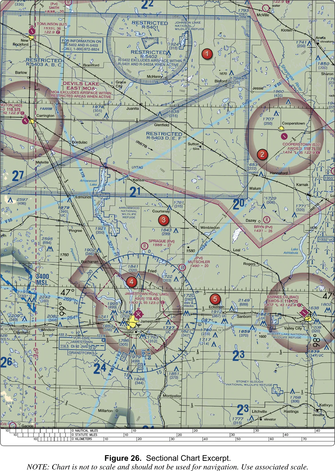
Figure 26 (plate 3-5) shows both faces side by side. Jamestown Regional (JMS, area 4) is ringed by a dashed magenta line with arms along the approaches: a Class E surface area. The test’s question about inspecting a tower at 46.9N, 98.6W near JMS has the answer “authorization from ATC,” and the point falls inside that dashed line. The military and the National Park Service are the distractors. At Cooperstown (S32, area 2) there is only a soft magenta ring: a 700-foot floor. Below 700 feet that ground is Class G, so the airspace class asks nothing of you.
Class G: uncontrolled, and where you will fly
Class G is whatever is left: the airspace that is not A, B, C, D, or E. It runs from the surface up to the base of the Class E above it, usually 700 or 1,200 feet AGL. In remote country where Class E is charted at 14,500 feet MSL it can be much thicker.
FAA-H-8083-25C, Ch. 15 · FAA Chart Users' Guide, Airspace“Uncontrolled” means ATC has no authority or responsibility to control traffic there. It does not mean anything goes. A remote pilot needs no ATC authorization in Class G, but everything else still applies: the 400-foot ceiling, line of sight, right-of-way, § 107.43 near airports, special use airspace, and any TFR. Even Class G can hold an airport with a tower; the FAA’s example is Lake City, Florida, a reminder to check the Chart Supplement and not assume.
FAA-G-8082-22, Ch. 2 · FAA-H-8083-25C, Ch. 15The numbers at a glance
| Class A | 18,000 ft MSL up to FL 600 | FAA-H-8083-25C, Ch. 15 |
|---|---|---|
| Class B | Surface to about 10,000 ft MSL, in tiers | FAA-H-8083-25C, Ch. 15 |
| Class C core | Surface to 4,000 ft above airport, 5 NM radius | FAA-H-8083-25C, Ch. 15 |
| Class C shelf | 1,200 to 4,000 ft above airport, 10 NM radius | FAA-H-8083-25C, Ch. 15 |
| Class D | Surface to 2,500 ft above airport, about 4 NM | FAA-H-8083-25C, Ch. 15 |
| Class E surface area | Surface up, dashed magenta | FAA Chart Users’ Guide |
| Class E floor, airport with instrument approach | 700 ft AGL, magenta vignette | FAA Chart Users’ Guide |
| Class E floor, default | 1,200 ft AGL | FAA-H-8083-25C, Ch. 15 |
| Class E where no floor is charted | 14,500 ft MSL | FAA-H-8083-25C, Ch. 15 |
| Class G | Surface to the base of Class E | FAA-H-8083-25C, Ch. 15 |
| Mode C veil | 30 NM around a Class B primary airport, to 10,000 ft MSL | FAA Chart Users’ Guide |
| Your ceiling | 400 ft AGL | 14 CFR § 107.51(b) |
| Class B | Solid blue line, blue numbers | Chart Users’ Guide |
|---|---|---|
| Class C | Solid magenta line, magenta numbers | Chart Users’ Guide |
| Class D | Dashed blue line, ceiling in a dashed bracket | Chart Users’ Guide |
| Class E surface area | Dashed magenta line | Chart Users’ Guide |
| Class E, 700 AGL floor | Magenta vignette (fade) | Chart Users’ Guide |
| Class E, 1,200 AGL floor next to G | Blue vignette | Chart Users’ Guide |
| Class G | No line: whatever the rest does not cover | Chart Users’ Guide |
Weather minimums in this context
For manned aircraft the visibility and cloud-clearance numbers change with the class and altitude. A pilot below 10,000 feet in Class E needs three miles of visibility and must stay 500 feet below, 1,000 above, and 2,000 feet horizontally from clouds. In Class G at or below 1,200 AGL by day it relaxes to one mile and clear of clouds.
FAA-H-8083-25C, Ch. 15 (Fig. 15-8)You do not have to learn that table. Part 107 replaces it with one set of numbers that applies in every class: at least three statute miles of flight visibility, measured from the control station; at least 500 feet below a cloud; at least 2,000 feet horizontally from it. There is no “above” number in your rule. The reason for the cushion: a manned aircraft can drop out of a cloud at 150 knots with no way to see you, and the buffer is the time a pilot needs to spot and avoid a small object.
14 CFR § 107.51(c) · 14 CFR § 107.51(d)§ 3.3 — PERMISSION
Permission: § 107.41, LAANC, and who else you must ask
Which classes need authorization
Section 107.41 is short enough to memorize: no one may operate a small unmanned aircraft in Class B, Class C, or Class D airspace, or within the lateral boundaries of the surface area of Class E airspace designated for an airport, unless that person has prior authorization from ATC.
14 CFR § 107.41The word the test leans on is prior. Calling the tower after you launch does not count. Monitoring the tower frequency from launch to landing does not count. You get permission, then you fly. The flip side is just as firm: unless the flight is within controlled airspace, no notification or authorization is necessary to operate at or near an airport.
AC 107-2A, § 5.10, § 5.10.1| Class B, C, or D | Yes | § 107.41 |
|---|---|---|
| Class E surface area (dashed magenta) | Yes | § 107.41 |
| Class E with a 700 or 1,200 AGL floor | No, at or below 400 ft AGL | FAA-G-8082-22, Ch. 2 |
| Class G | No | FAA-G-8082-22, Ch. 2 |
| Prohibited or restricted area | Permission from the using or controlling agency, not ATC | § 107.45 |
| TFR | Comply with the NOTAM, §§ 91.137 to 91.145 and 99.7 | § 107.47 |
An authorization is not a blank check. The FAA says ATC authorizations may depend on operational parameters like those in Part 91, and that it can approve or deny an operation based on traffic density, controller workload, communication issues, or anything else affecting the safe and expeditious flow of air traffic.
AC 107-2A, § 5.10Equipment does not substitute for authorization either. A geofence or other onboard mitigation does not remove the requirement, and the FAA does not review equipage when deciding on authorizations. A pilot who wants to operate in controlled airspace on the strength of equipment applies for a certificate of waiver instead.
AC 107-2A, § 5.10.2How authorization works in practice
The regulation says “authorization from ATC.” The practical question is how you get one without phoning a tower. In day-to-day practice there are two routes: LAANC, an automated check done through an approved smartphone app, and a manual request filed through the FAA’s DroneZone website for cases the automated system does not cover.
LAANC stands for Low Altitude Authorization and Notification Capability. You open an approved app, draw your flight area, enter altitude and time, and often get an answer within seconds. The system works from FAA-prepared maps that give a maximum altitude for each grid square around an airport, and approves anything at or below that number. Where the map says zero, automated approval is not available.
Further coordination covers requests above the map’s number or in places LAANC does not reach. You file through the FAA DroneZone and a human answers. Plan for days, not minutes. DroneZone is also where registration lives, so you may already have an account. An authorization is specific to a place, an altitude, and a window of time; fly inside it.
AC 107-2A, § 2.3.2, § 5.10§ 3.4 — SPECIAL USE AIRSPACE
Special-use airspace
Special use airspace (SUA) is airspace in which certain activities must be confined, or where limits may be placed on aircraft that are not part of those activities. It is where the military tests weapons, trains pilots, and protects sensitive sites. The FAA lists six types: prohibited, restricted, warning, military operations areas (MOAs), alert, and controlled firing areas. Five are drawn on charts. The sixth is not, for a reason you will see.
FAA-H-8083-25C, Ch. 15The chart prints each area’s name or number, and its margin tabulation lists altitudes, times of use, and the controlling agency. The chart’s own text points out that no NOTAM will be issued to announce permanently listed times of use. If the chart says an area is active on weekdays, nothing will tell you it is Monday.
FAA Chart Users' Guide, Chart TabulationsProhibited and restricted areas
In a prohibited area the flight of aircraft is prohibited. These areas exist for security or other reasons tied to national welfare, are published in the Federal Register, and are charted as “P” and a number. The FAA’s examples are P-40 at Camp David and the airspace over the National Mall in Washington.
A restricted area is airspace where flight is not wholly prohibited but is subject to restrictions, because of often invisible hazards: artillery firing, aerial gunnery, guided missiles. It is charted “R” and a number, such as R-4401. Entering without permission from the using or controlling agency may be extremely hazardous.
FAA-H-8083-25C, Ch. 15Notice what § 107.45 says: no person may operate a small unmanned aircraft in a prohibited or restricted area unless that person has permission from the using or controlling agency. Not ATC. A restricted area may be inactive, or released to the FAA for instrument traffic, but that arrangement is between ATC and airplanes. For you the rule is permission, from the agency the chart names.
14 CFR § 107.45Look at the northwest corner of Figure 26 (plate 3-5). Restricted areas R-5401, R-5402, and R-5403 are outlined in blue, with a note that R-5402 excludes the airspace of R-5401 and R-5403A when they are active, and a telephone number for information. The legend uses the same blue hatching for prohibited, restricted, and warning areas.
Warning areas
A warning area is like a restricted area with one difference: the U.S. government does not have sole jurisdiction over it. Warning areas begin 3 nautical miles from the coast, may sit over domestic or international waters, and are charted “W” and a number, such as W-237. They exist to warn nonparticipating pilots of the danger.
FAA-H-8083-25C, Ch. 15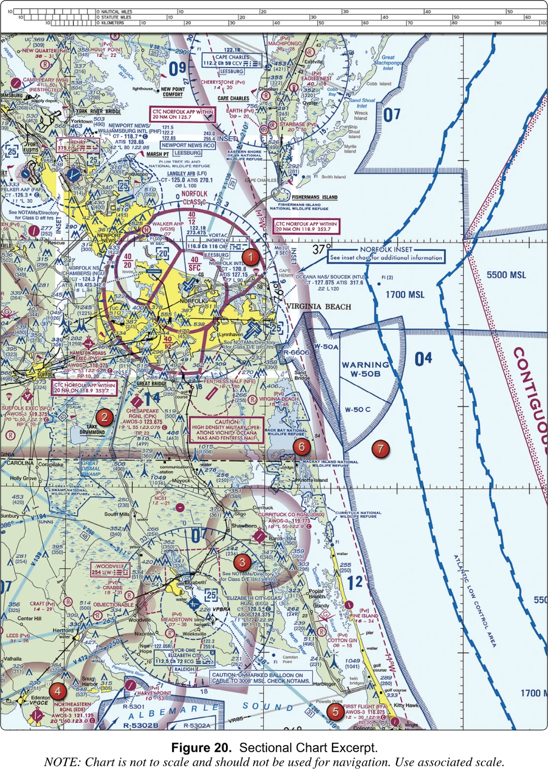
Figure 20 (plate 3-6) shows W-50A, W-50B, and W-50C off the Virginia Beach coast, next to restricted area R-6606. It also carries a caution box, “High density military operations vicinity Oceana NAS and Fentress NALF.” That one is a hazard note, not a boundary.
Military operations areas
A MOA is airspace with defined vertical and lateral limits, established to separate certain military training from IFR traffic. MOAs are named, not numbered (“Camden Ridge MOA”), and charted in magenta, and the tabulation gives times and altitudes. Part 107 does not forbid a drone in a MOA the way § 107.45 does in a restricted area. But an active MOA means military training overhead and sometimes low, which is not where you want to be surprised.
FAA-H-8083-25C, Ch. 15Floors matter. On Figure 23 the label “Bulldog C MOA excludes airspace 1,500’ AGL and below” tells you the ground-level airspace there is outside the MOA. On Figure 26 the Devils Lake East MOA overlies the restricted areas, and its note excludes the airspace within them when they are active.
The FAA’s sample question asks how you would find out whether a MOA is active. The answer is on the chart itself, in its legend and margin tabulation. The wrong answers invent places that do not exist: a “Small UAS database,” a “Military Operations Directory.”
Alert areas and controlled firing areas
An alert area is charted “A” and a number (A-211) to tell pilots the area may contain a high volume of pilot training or an unusual type of aerial activity. You are not barred from alert areas. You are expected to be careful, and everyone, including participating aircraft, is equally responsible for collision avoidance. Alert areas do not extend into Class A, B, C, or D, or into Class E surface areas.
FAA-H-8083-25C, Ch. 15 · FAA Chart Users' Guide, AirspaceA controlled firing area (CFA) holds activity that would be hazardous to nonparticipating aircraft if it were not done in a controlled setting. What sets it apart: activity stops immediately when a spotter aircraft, radar, or a ground lookout says an aircraft might be approaching. Because nobody has to change their path, a CFA is not charted at all. If a question asks how to find one on a sectional, the answer is that you cannot.
FAA-H-8083-25C, Ch. 15 · FAA Chart Users' Guide, Special Use Airspace§ 3.5 — OTHER AIRSPACE AREAS
Other airspace areas
Military training routes
Military training routes (MTRs) are paths the military uses to practice low, fast tactical flying, generally below 10,000 feet MSL at more than 250 knots. They are named IR (instrument) or VR (visual) followed by a number, and the number carries a message. A four-digit route, like VR1667, has no segment above 1,500 feet AGL. A route with three or fewer digits has at least one segment above 1,500.
FAA-H-8083-25C, Ch. 15 · FAA Chart Users' Guide, Other Airspace AreasWhy would a drone pilot care? At 250 knots a jet covers 2,000 feet in under five seconds. A four-digit route puts that aircraft at or below 1,500 feet AGL, which includes your 400-foot layer, and you will not see it coming. MTRs are charted as a line along the route with arrowheads for direction of flight, and routes have a width that can reach several miles either side of the line.
The test’s sample on Figure 59 (Toledo, Ohio) shows a gray line labeled VR1667, VR1617, VR1638, and VR1668 and asks whether it could be a hazard to a small UA. Yes: four digits means the route runs from the surface to 1,500 feet AGL, which includes where you fly. The answer “all operations will be above 400 feet” is wrong for the same reason.
FAA-CT-8080-2H, Fig. 59 · FAA Chart Users' Guide, Other Airspace AreasSome routes carry a “Special Military Activity” note with a radio frequency to call for activity status, because the military also flies unmanned aircraft along some routes and MOAs.
National security areas, TRSAs, and the rest
National security areas (NSAs) are drawn with a broken magenta line. They exist where a facility needs extra security, and pilots are requested to avoid them. Under Part 99, flight there may be temporarily prohibited by NOTAM.
Terminal radar service areas (TRSAs) are places where participating pilots can get extra radar service. Participation is voluntary. The main airport becomes Class D, and the rest of the TRSA overlies other airspace, normally Class E.
Published VFR routes (flyways, corridors, transition routes) help manned pilots go around, under, or through complex airspace and appear mostly on terminal area charts. Airport advisory service is a service from a flight service station at an airport, providing local conditions when the tower is not available.
FAA-H-8083-25C, Ch. 15 · FAA Chart Users' Guide, Other Airspace AreasParachute jump areas, gliders, hang gliders, ultralights, and unmanned aircraft activity each have a chart symbol, and Legend 1 shows them all. Parachute operations are published in the Chart Supplement, and the frequently used sites appear on the sectional. A parachute jump in or into Class A, B, C, or D needs ATC authorization. Gliders, hang gliders, and ultralights share a trait: they cannot easily climb away from a surprise. Treat each symbol as a sign that the low air there is shared with people who cannot easily dodge you.
FAA-H-8083-25C, Ch. 15 · FAA-CT-8080-2H, Legend 1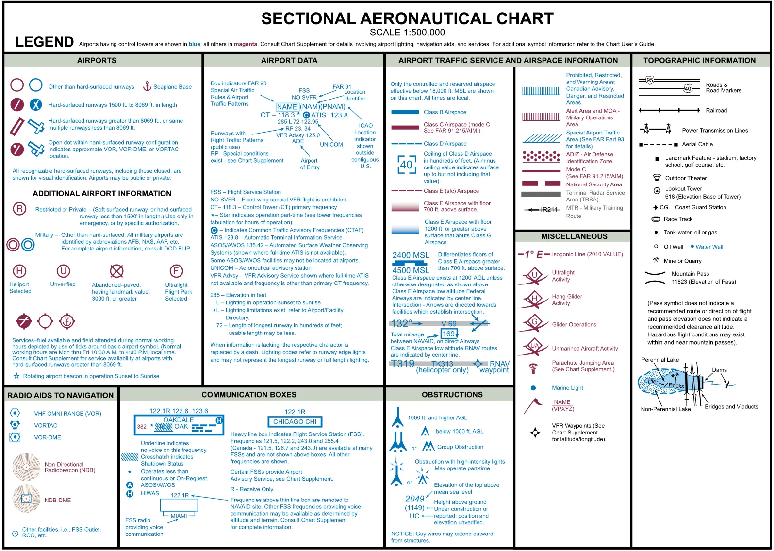
Legend 1 (plate 3-7) is the reference to learn to use, not to memorize. It is where you confirm that blue hatching is P, R, and W while magenta hatching is alert and MOA, and where you decode the numbers beside obstructions. In the test room it is in the supplement and open at any time.
§ 3.6 — TFRS AND NOTAMS
Temporary restrictions and NOTAMs
Temporary flight restrictions
A temporary flight restriction (TFR) is a restriction that exists for a limited time because something has happened or is about to: a wildfire, a hurricane, a visit by the President, a rocket launch, a sporting event. The FAA issues each TFR as a Notice to Airmen. Section 107.47 makes it binding on you: a remote pilot in command must comply with §§ 91.137 through 91.145 and § 99.7.
14 CFR § 107.47The FAA lists these purposes: protecting people and property from an existing or imminent hazard; giving disaster relief aircraft a safe environment; preventing unsafe congestion of sightseeing aircraft over an event of public interest; protecting declared national disasters in Hawaii; protecting the President, Vice President, or other public figures; and giving space operations a safe environment.
FAA-H-8083-25C, Ch. 15The why is easy to feel at a wildfire. Firefighting aircraft work low, slow, and often in smoke. A drone sent up for pictures is a collision waiting to happen, and § 107.37 already tells you to yield to every aircraft. A TFR turns that principle into a boundary on a map, so nobody has to judge the situation in the air.
A TFR NOTAM begins with the words “FLIGHT RESTRICTIONS,” followed by the location, the effective period, the area in statute miles, and the altitudes affected. It names the FAA coordination facility and a phone number, and gives the reason.
FAA-H-8083-25C, Ch. 15Only a few TFRs appear on a chart. Those relating to national security are drawn with a broken blue line, and routine national defense TFRs lasting 12 months or more are cross-hatched. Sporting event sites have a symbol. Everything else, including the wildfire that started yesterday, appears only in NOTAMs. You find them at tfr.faa.gov or in a Flight Service briefing. The FAA notes that TFR incursions have led to security investigations and certificate suspensions.
FAA Chart Users' Guide, Airspace · FAA-H-8083-25C, Ch. 15 · AC 107-2A, § 5.10.3NOTAMs
A Notice to Airmen (NOTAM) is time-critical aeronautical information that is temporary or not known far enough ahead to be printed on a chart. The reason it exists is the print schedule. Sectional charts are revised semiannually. If a crane goes up or a runway closes next Tuesday, the chart is wrong the moment it is printed, so the NOTAM system distributes the change at once.
FAA-G-8082-22, Ch. 2, Ch. 11The FAA’s examples of what NOTAMs announce: hazards such as air shows, parachute jumps, kite flying, and rocket launches; flights by important people; inoperable lights on tall obstructions; temporary obstacles near airfields; and flocks of birds (a BIRDTAM). The same system reports airport closures, construction, and changes in navigation aid status.
FAA-G-8082-22, Ch. 2How to get them: through PilotWeb, or through a briefing from Flight Service at 1800wxbrief.com, which the FAA names as the place to check NOTAMs, TFRs, and weather. Local airport NOTAMs are on several websites. The duty is stated plainly in AC 107-2A: the remote pilot in command must check NOTAMs before each flight to determine whether any airspace restrictions apply.
AC 107-2A, § 2.2, § 5.10.3Back to Figure 20 (plate 3-6). The caution box near Elizabeth City reads, in effect, “Unmarked balloon on cable to 3008’ MSL. Check NOTAMs.” One sample question asks how a remote pilot checks NOTAMs, and the answer is a briefing from an online source such as 1800wxbrief.com; the distractors are the B4UFLY app and a call to the district office. Another asks what hazard is indicated, and the trick is the unit: MSL, not AGL.
§ 3.7 — THE AIRPORT ENVIRONMENT
The airport environment
Why 400 feet is not low near a runway
Every aircraft that takes off or lands has to pass through your altitude. That is the central fact of this section. A departing airplane climbs through 400 feet AGL within moments of liftoff. An arriving airplane descends through it in its last seconds. On a standard three-degree glide path an aircraft is about 400 feet above the runway roughly 1.3 nautical miles out. (That is arithmetic, not an FAA rule: 400 feet divided by the tangent of three degrees.) At that moment the pilot is at their busiest, slowest, and closest to the ground, looking at the runway and not at the sky off to the side.
So airports concentrate the aircraft you are least able to avoid, at the altitude where you fly. That is why the regulation addresses airports directly.
Section 107.43 and what “interfere” means
No person may operate a small unmanned aircraft in a manner that interferes with operations and traffic patterns at any airport, heliport, or seaplane base. It applies in every class, controlled or not: “no authorization needed” is not “no obligation.”
14 CFR § 107.43The key word is interferes, which is wider than collision. The FAA’s illustration: a drone hovering 200 feet above a runway might present no conflict to an aircraft on downwind and might not violate the right-of-way rule, yet a manned aircraft holding short might delay its takeoff and another might delay its landing. That is interference. The test is whether a manned pilot had to change plans because of you. The FAA says to avoid traffic patterns and published approach corridors, and where you must work at an airport in uncontrolled airspace, to operate so that no manned pilot has to alter a flight path or an instrument approach.
AC 107-2A, § 5.10.1, § 5.10.1.1, § 5.10.1.2Right-of-way sits beside it. Under § 107.37 you yield to all aircraft, which means you may not pass over, under, or ahead of one unless well clear. See the right-of-way lesson.
14 CFR § 107.37(a)The traffic pattern
A traffic pattern is a rectangular racetrack flown around a runway so that every aircraft arriving or departing at that airport moves in the same direction through the same places, where everyone expects them. Airplanes fly it with left turns unless the airport shows otherwise, and the chart marks runways that use right-hand patterns with “RP.” The legs have names you will hear on the radio: upwind, crosswind, downwind, base, final. A call like “midfield left downwind runway 13” places an aircraft on the downwind leg, abeam the middle of the runway. The lesson on the traffic pattern and runways draws it.
FAA-G-8082-22, Ch. 7 · FAA-H-8083-25C, Ch. 15At an airport with no tower, manned pilots broadcast on a common frequency (the CTAF), which may be a UNICOM, MULTICOM, flight service, or tower frequency. The chart prints it near the airport, and where nothing is listed the MULTICOM frequency is 122.9. Pilots are not required to make those calls, though it is good practice. A remote pilot is not expected to talk on aviation frequencies and should not, except in an emergency, but listening gives you another layer of awareness.
FAA-G-8082-22, Ch. 7The dangerous assumption is that quiet means empty. The FAA notes that some aircraft have no radio and some pilots do not announce themselves. Your eyes, scanning the whole sky, are the actual safeguard.
Where to read about a specific airport
Three sources and a habit. The sectional chart shows whether an airport has a tower (blue symbols are towered, magenta are not), its CTAF, and the airspace around it. The Chart Supplement U.S., revised every 56 days, gives the most comprehensive information on an airport. NOTAMs carry what has changed. ATIS, a recorded broadcast, gives current weather and runways in use. The habit is checking all of them, because each fails where the others hold.
FAA-G-8082-22, Ch. 11 · FAA-CT-8080-2H, Legend 1§ 3.8 — OTHER FLIGHT HAZARDS
Other flight hazards
The ACS lists a group of potential flight hazards. Some you can see on the ground. Some you cannot.
FAA-S-ACS-10B, Area II, Task BBalloons, wires, and towers
Unmanned balloons. Avoid flying beneath them. A free balloon’s payload hangs below it, and a tethered balloon puts a cable into the sky. The FAA notes that tethered balloons for observation and weather recording can extend on cables up to 60,000 feet. The caution box on Figure 20 is a chart example. Unless ATC authorizes it, an unmanned free balloon may not operate below 2,000 feet above the surface within the lateral boundaries of Class B, C, D, or the surface area of Class E.
FAA-H-8083-25C, Ch. 15 · FAA-G-8082-22, Ch. 2The wire environment. The FAA safety alert SAFO 10015, “Flying in the Wire Environment,” is on the ACS reference list. Power lines, guy wires, and cables are thin enough to be nearly invisible until you are on top of them. The FAA’s guidance on skeletal towers: guy wires can extend about 1,500 feet horizontally from the structure, so keep at least 2,000 feet away horizontally, and expect them to vanish at dusk and in poor visibility. A new tower may not yet be on your chart.
FAA-G-8082-22, Ch. 11 · FAA-S-ACS-10B, App. A (SAFO 10015)Reading obstruction symbols. An obstruction is a small spike symbol, taller for 1,000 feet AGL and higher. Beside it are two numbers: the elevation of the top in MSL, and in parentheses the height above ground. “UC” means under construction or reported, with unverified position and elevation. A starburst marks an obstruction with high-intensity lights, which may operate part-time. The legend adds that guy wires may extend outward from structures.
FAA-CT-8080-2H, Legend 1Lighting helps a pilot find a structure but is no guarantee. A NOTAM may report a tower’s lights as out, and some structures have no lights at all. Assume that the wire, pole, or antenna on your route does not have a light on it, and survey the site in daylight. That is the practical content of “hazards on the ground that do not have lighting.”
FAA-G-8082-22, Ch. 2 · AC 107-2A, App. AThermal plumes, lasers, static, and the rest
Thermal plumes rise from smokestacks and cooling towers: columns of hot, rising, turbulent air. A small aircraft in one can be pushed up or down suddenly. Keep well clear, beside and above.
FAA-S-ACS-10B, Area II, Task B (general knowledge · see note)Lasers can dazzle or injure a pilot’s eyes. Laser operations are announced by NOTAM, and illumination of an aircraft is something to report. You should never fly into a published laser operations area, and never point anything at a manned aircraft.
FAA-S-ACS-10B, Area II, Task B (general knowledge · see note)Precipitation static is the electrical charge an aircraft picks up in rain, snow, or dust, and it shows up as radio noise. For a drone it is one more reason not to fly in precipitation.
FAA-S-ACS-10B, Area II, Task B (general knowledge · see note)Emergency airborne inspection of other aircraft is something one manned aircraft does for another. A small drone has no part in it. Your rule is § 107.37(b): no person may operate a small unmanned aircraft so close to another aircraft as to create a collision hazard.
14 CFR § 107.37(b)Common accident causes in manned aviation are mostly human: poor decisions, loss of control, flight into obstacles and weather. The same holds for you, and the operations chapter takes it up.
FAA-S-ACS-10B, Area II, Task B (general knowledge · see note)Seeing and being seen at night
For your aircraft the rule is § 107.29: during civil twilight and at night, a small unmanned aircraft must have lighted anti-collision lighting visible for at least 3 statute miles, with a flash rate sufficient to avoid a collision. The remote pilot may reduce the intensity of the light but may not extinguish it, if conditions make that safer. Civil twilight is the 30 minutes before official sunrise and the 30 minutes after official sunset.
14 CFR § 107.29(a)(2) · 14 CFR § 107.29(b) · 14 CFR § 107.29(c)For the operator, the equipment that matters is your own eyes and what you do to them. The rods in the eye can take about 30 minutes to adapt fully to darkness, and a bright light can destroy that adaptation. The FAA advises keeping lighting low and using a dim white light for charts and checklists. AC 107-2A also names unlit towers and buildings as a night hazard, which leads back to the survey in daylight.
FAA-H-8083-25C, Ch. 17 · AC 107-2A, App. AManned aircraft carry their own lights, and they tell you which way the aircraft is heading: a red light on the left wingtip, green on the right, white at the tail, plus flashing anti-collision lights. Red and green together mean the aircraft is pointed toward you. That is general knowledge, not from the FAA documents here.
General aviation knowledge (see the closing note)§ 3.9 — PUTTING IT TOGETHER
Finding all of this, and a routine
Where the information lives
No single source shows the whole picture, so you use a short list, each good at one thing.
The sectional chart shows the permanent layers: classes, special use airspace, MTRs, obstructions, airports. It is revised twice a year, so it is accurate on its print date and slowly less so after. Read it with Legend 1 beside it. The FAA tells remote pilots to know the airports, airspace, navigational and procedural, and other symbols on the chart; the Chart Users’ Guide explains them one by one, and the sectional chart chapter teaches the reading.
The Chart Supplement U.S. adds airport detail the chart cannot hold. NOTAMs and TFRs (tfr.faa.gov or a 1800wxbrief.com briefing) add the temporary layer. B4UFLY, the FAA’s mobile app, and other airspace apps give a quick answer to what kind of airspace is here. AC 107-2A says that referring to B4UFLY or a current aeronautical chart will aid your decisions. Treat the app as a first look and the chart as the thing you can be asked about.
AC 107-2A, § 5.10.4, § 2.3.2 · FAA-G-8082-22, Ch. 2A routine before every flight
Five questions, in order. None takes more than a minute.
First, what class of airspace am I in, at my altitude? Find your launch point on the chart or in an airspace tool. If it sits inside solid blue, solid magenta, dashed blue, or dashed magenta, you probably need authorization before launch.
Second, is there special use airspace or an MTR over or beside my work area? If so, read the tabulation for hours, altitudes, and who to call. For a prohibited or restricted area, permission comes from the using or controlling agency.
Third, is there a TFR or NOTAM today? Check every time. The chart cannot tell you.
Fourth, where is the nearest airport, and where do aircraft arriving or leaving it pass? Stay out of the pattern and the approach corridors, and do not make anyone change plans.
Fifth, what is on the ground and in the low air that is not on the chart, such as new towers, wires, and balloon cables? A daylight survey is the cheapest safety device you own.
14 CFR § 107.49(a) · AC 107-2A, § 5.10, § 5.11You should now be able to
- Identify Class A, B, C, D, E, and G by dimensions, line style, and chart numbers, and read a ceiling and floor off a sectional.
- Determine from a chart or description whether § 107.41 requires prior ATC authorization, and explain how LAANC and DroneZone requests fit in.
- Distinguish prohibited, restricted, warning, MOA, alert, and controlled firing areas, and say who gives permission under § 107.45.
- Explain military training routes, parachute areas, TRSAs, national security areas, and published VFR routes, including the VR1667 style of designator.
- Explain what a TFR is under § 107.47, and obtain TFRs and NOTAMs before flight through Flight Service.
- Describe airport traffic patterns and § 107.43, and explain why the sky near a runway is hazardous at 400 feet.
- Recognize flight hazards: unmanned balloons, wires, towers, thermal plumes, lasers, and unlit ground structures.
- State the Part 107 anti-collision lighting rule for civil twilight and night, and the basic weather minimums that apply in any class.